Data Descriptor

A Dataset of Non-Indigenous and Native Fish of the Volga and Kama Rivers (European Russia)

by
Dmitry P. Karabanov
1,2,*,
Dmitry D. Pavlov
1,
Yury Y. Dgebuadze
2,
Mikhail I. Bazarov
1,
Elena A. Borovikova
1,
Yuriy V. Gerasimov
1,
Yulia V. Kodukhova
1,
Pavel B. Mikheev
3,
Eduard V. Nikitin
4,
Tatyana L. Opaleva
5,
Yuri A. Severov
6,
Rimma Z. Sabitova
1,
Alexey K. Smirnov
1,
Yury I. Solomatin
1,
Igor A. Stolbunov
1,
Alexander I. Tsvetkov
1,
Stanislav A. Vlasenko
4,
Irina S. Voroshilova
1,
Wenjun Zhong
7,
Xiaowei Zhang
7 and
Alexey A. Kotov
2,*
add Show full author list remove Hide full author list
1
Papanin Institute for Biology of Inland Waters of Russian Academy of Sciences, 152742 Borok, Russia
2
A.N. Severtsov Institute of Ecology and Evolution of Russian Academy of Sciences, 119071 Moscow, Russia
3
Perm State University, 614038 Perm, Russia
4
Volga-Caspian Branch FGBNU “VNIRO”, 105187 Astrakhan, Russia
5
Independent Researcher, 614000 Perm, Russia
6
Tatar Branch FGBNU “VNIRO”, 420029 Kazan, Russia
7
State Key Laboratory of Pollution Control & Resource Reuse, School of the Environment, Nanjing University, Nanjing 210023, China
*
Authors to whom correspondence should be addressed.
Data 2023, 8(10), 154; https://doi.org/10.3390/data8100154
Submission received: 25 July 2023 / Revised: 21 September 2023 / Accepted: 29 September 2023 / Published: 18 October 2023

Abstract

:
Fish in the Volga-Kama River System (the largest river system in Europe) are important as a crucial food source for local populations; fish have the highest trophic level among hydrobionts. The purpose of this research is to describe the diversity of non-indigenous and native fish in the Volga and Kama Rivers, in the European part of Russia. This dataset encompasses data from June 2001 to September 2021 and comprises 1888 records (36,376 individual observations) for littoral and pelagic habitats from 143 sampling sites, representing 52 species from 42 genera in 22 families. The dataset has a Darwin Core standard format and has been fully released in the Global Biodiversity Information Facility (GBIF) under CC-BY 4.0 International license. The data are validated with several international databases such as FishBase, Eschmeyer’s Catalog of Fishes, the Barcode of Life Data System, and the SAS.Planet geoinformations system. Newly established populations have been found for several species belonging to the following Actinopteri families: Alosidae, Anguillidae, Cichlidae, Ehiravidae, Gobiidae, Odontobutidae, Syngnathidae, and Xenocyprididae. Therefore, this dataset can be used in the particular taxon species distribution analysis, which are especially important for non-indigenous species.
Dataset License: Creative Commons Attribution (CC-BY) 4.0 International License

1. Summary

The appearance and naturalization of different organisms in regions out of their initial distribution ranges, including human-mediated biological invasions, is regarded among the main recent challenges for humanity. The “Convention on Biological Diversity” declares that each contracting party shall apply “prevention, early detection and warning, eradication and/or control of invasive alien species” [1]. In Russia, such an approach is enshrined in the “Ecological Doctrine of the Russian Federation” [2].
The fish community plays an important role in the functioning of the freshwater ecosystem by regulating the substance and energy flows; fish represent the highest trophic level in the ecosystems of continental waters [3]. Moreover, fisheries in continental water bodies are very important for food security and rational nature management [4]. This is especially true in regard to the Volga–Kama basin, being the largest freshwater system in Russia and in Europe.
As 40% of the population of Russia lives in the Volga basin, this water system suffers from strong anthropogenic pressure. According to different taxonomic and faunistic accounts, from 120 to 140 fish species inhabit the basin: such variation in the number reflects the continuous revision of the taxonomic status of many species and subspecies [5]. Fish communities are strongly changing due to the global anthropogenic transformation of the river systems. There are 12 hydro-power stations and 28 water reservoirs and waterworks through the total length of the Volga (3530 km) and Kama (1805 km) Rivers, which were constructed in the 20th century. These reservoirs occupy large areas, differ in environmental conditions and trophic status, and have different morphologies of the littoral zone, providing various biotopes and ecological niches for the establishment of non-indigenous species populations. After flow regulation, the fish community was changed due to the replacement of rheophilous fauna by limnophylous species. This change was almost finished in the last quarter of the 20th century, when the water reservoir ecosystem acquired a stable state. But at the beginning of the 21st century, rapid density growth of the non-indigenous species started, firstly affecting the brackish Ponto-Caspian taxa and some exotic forms [6]. Also, species from the Azov–Black Sea system, as well as from the northern water systems, have expanded their distribution areas the towards north and south [7,8]. Few species were directly introduced, occasionally or deliberately, by humans as a result of aquaculture development [9,10]. As a result, in some water reservoirs, up to 30% of species are non-indigenous to date [11].
Updating information on non-indigenous species is very important for biodiversity assessment in the region and a prognosis of the consequences (not always negative) of exotic taxon introduction [12]. There are many papers reporting on new records of non-indigenous taxa in different areas of the Volga–Kama basin [13,14,15]. These studies are performed using different methods; several articles summarizing available information on invasive species have been published to date [16,17]. But such investigations were not accompanied by a mass deposition of the initial information on the records of native and non-indigenous species with accurate geo-positions of the localities to international databases, like the Global Biodiversity Information Facility (GBIF), to make these data available for their subsequent analysis by experts in ecology, genetics, statistics, etc.
In this Data Descriptor paper, we describe the data of our studies, based on more than 36 thousand records during 2001–2021 in the Volga–Kama Region. Most attention was paid to non-indigenous species, for which osteological study and DNA barcoding were added to the standard method of ichthyological analysis [18]. All indigenous species were identified based on morphological characters, and osteological analysis was also performed for some populations. Each taxon was specially reviewed, and the dataset was deposited to GBIF and can be downloaded at https://www.gbif.org/dataset/adc2f4e2-12a8-4076-83ee-7d62b4dcc569 (accessed on 1 July 2023). All users can access the data under the Creative Commons Attribution (CC-BY) 4.0 International license. A yearly update to include newly digitized data deposited to GBIF will be carried out. Overall, this dataset contributes to the baseline information on freshwater fish biodiversity for future research.

2. Data Description

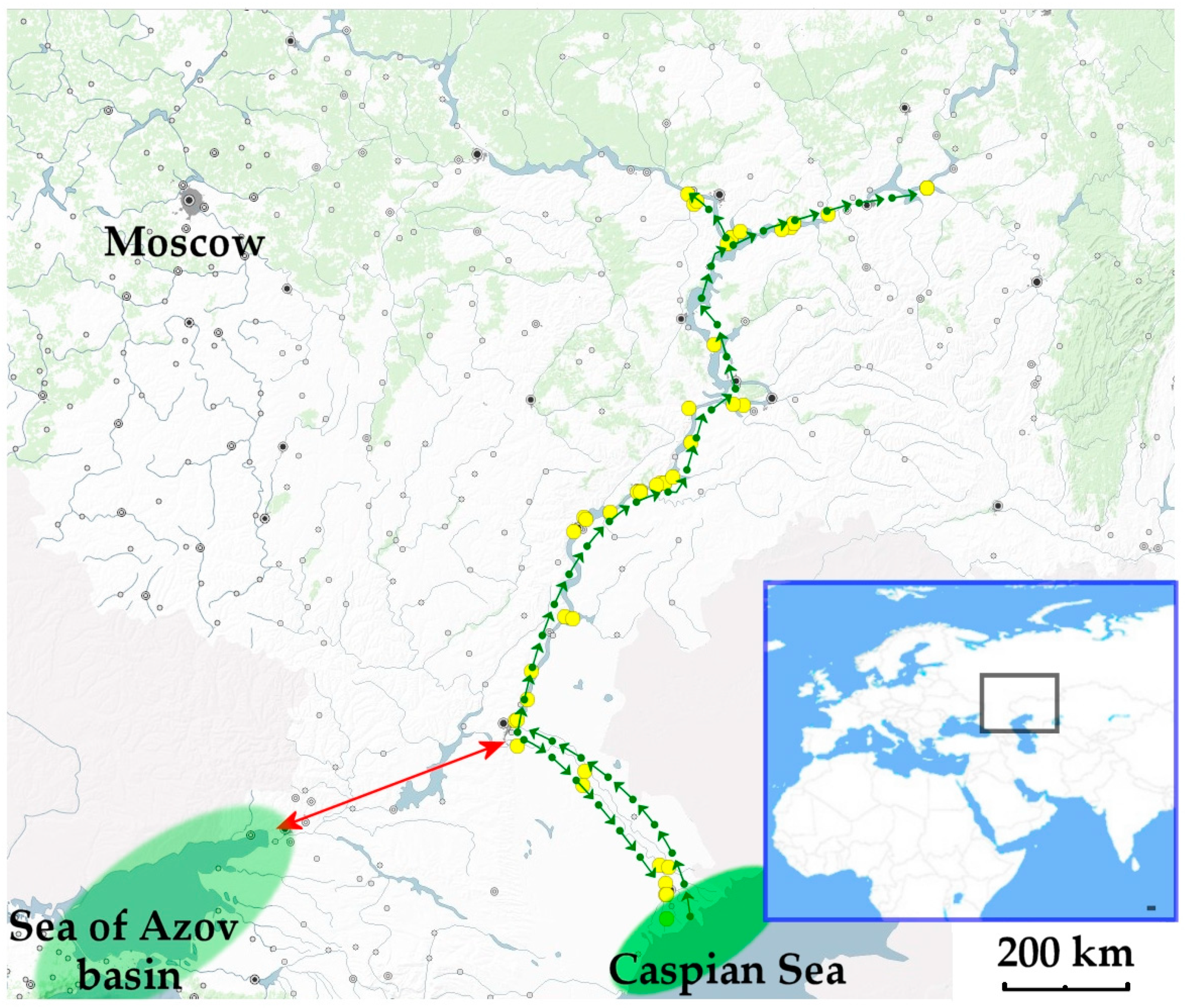
2.1. Geographical Description

The catchment of the study area was on the Russian plain [8]. The Volga area included the following reservoirs: Ivankovo, Uglich, Rybinsk, Gorky, Cheboksary, Kuybyshev, Saratov, Volgograd and the unregulated part, and the northernmost Sheksna reservoir on the Sheksna River. The Kama area included the upper part and the following reservoirs: Kama, Votkinsk, and Nizhnekamsk.

2.2. Bounding Coordinates

The Volga River basin’s (including Sheksna River in the north and Delta in the south) coordinates are as follows:
  • West 36.14 E
  • East 56.07 E
  • North 60.02 N
  • South 45.37 N
The Kama River basin’s coordinates are as follows:
  • West 49.24 E
  • East 56.28 E
  • North 59.26 N
  • South 55.15 N
The geographic coordinate system is WGS84.

2.3. Temporal Coverage

The study included data from June 2001 to September 2021.

2.4. Taxonomic Coverage
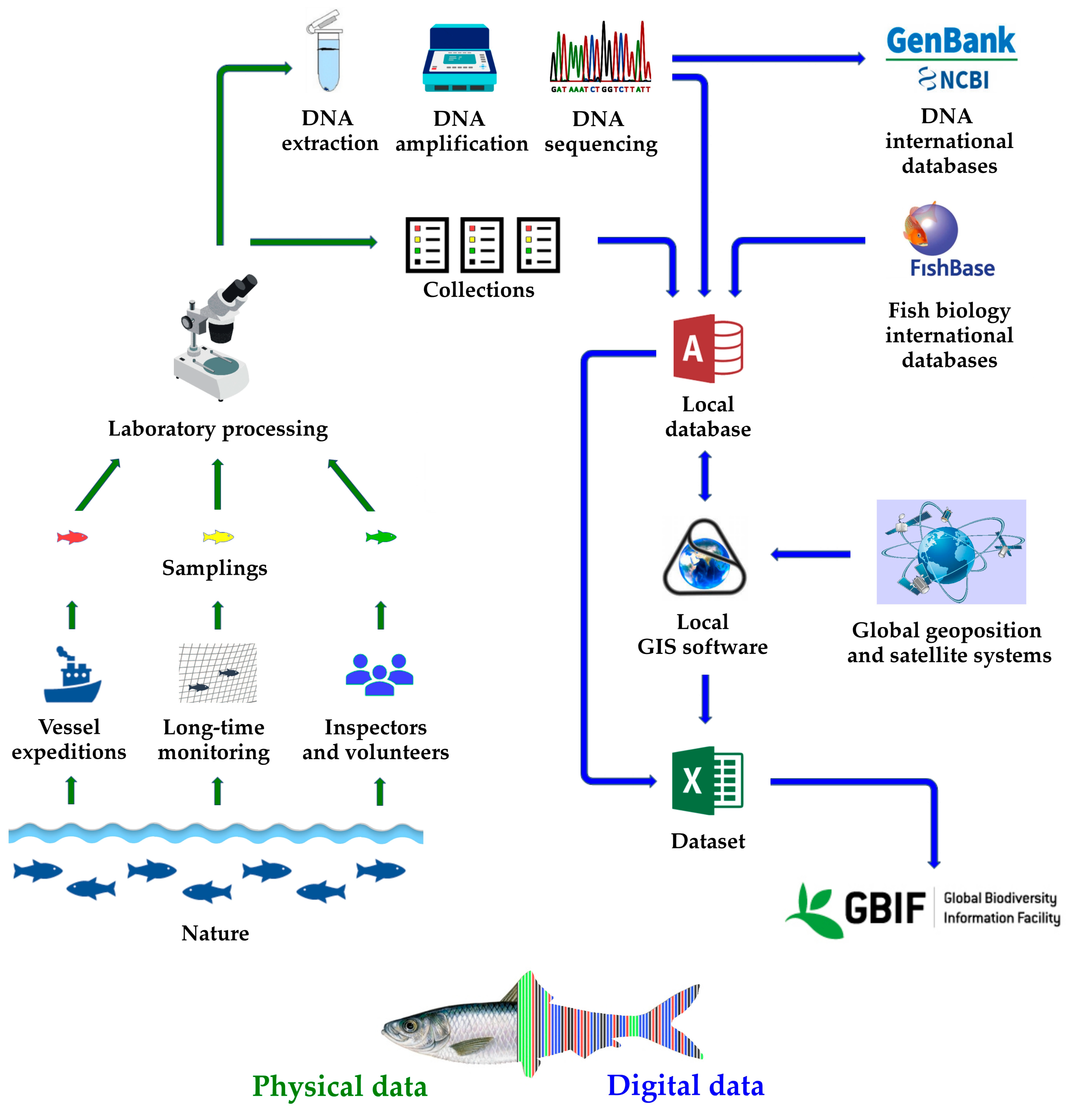
The dataset comprises 1888 records (36,376 individual observations) for littoral and pelagic habitats from 143 sampling sites, representing 52 species from 42 genera in 22 families.

2.5. Data Structure

The original dataset is a comma-separated values (CSV) text file according to Darwin Core terms defined by Biodiversity Information Standards (TDWG) [19]. The data file is text based in the UTF-8 encoding. Variable definitions are shown in Supporting Information Table S1. Descriptions in the Darwin Core were taken from the TDWG website (https://dwc.tdwg.org/terms/, accessed on 1 July 2023). For local geographic information systems, we attach a KLM file (Supporting Information File S1) according to keyhole markup language (KLM) standard ver.2.2 (http://www.opengis.net/kml/2.2, accessed on 1 July 2023). The presented data can be used by any user either from any local Geographic Information Systems (GIS) software or using the GBIF web interface (see Appendix A).

2.6. Accessibility

This dataset is provided under a Creative Commons Attribution 4.0 International License (CC-BY) 4.0 international; https://creativecommons.org/licenses/by/4.0/legalcode, (accessed on 1 July 2023).
The public location of storage is available at https://www.gbif.org/dataset/adc2f4e2-12a8-4076-83ee-7d62b4dcc569 (accessed on 1 July 2023).

3. Methods

Catching the samples was conducted by the Papanin Institute for Biology of Inland Waters of Russian Academy of Sciences (IBIW RAS) with a special Governmental Permit. Most samples from the Volga–Kama basin were caught during the Annual Complex Biological Expeditions of IBIW RAS based on an expedition vessel “Akademik Topchiev” in the summer field seasons (May–October) from 2001 to 2021 as well as through individual expeditions to the reservoirs (Figure 1). The network of stations was formed with the maximum coverage of the entire water area of each reservoir.
The littoral fishing was conducted using gear, including a beach seine with a size of 10 × 1.5 m, 4 mm mesh in the cod end and wings; a beach seine with dimensions of 25 × 1.7 m, 10 mm mesh in wings, 5 mm in the cod-end; a square fish lift net with a 1.5 m side, 4 mm mesh; and an ichthyological scoop-net with 4 mm mesh. The pelagic fish catching was performed using a midwater pelagic trawl with a horizontal opening of 12 m, a vertical opening of 1.5 m, and mesh in the cod end of 6 mm. The trawling was carried out 1–2 times at each station, depending on the number of horizons in which pelagic fishes were concentrated. Each trawling session took 5 to 12 min.
The main algorithm of the database formation is presented in Figure 2.
All collected specimens in the number recorded in the Darwin Core standard (DWC, [19]) formatted file (Supporting Information Table S1) were preserved for the laboratory analysis (frozen, fixed in ethanol, etc.). All specimens caught over these numbers were released to the environment with minimal damages. Specimens of protected, rare, and valuable species were photographed alive and released into the wild. All operations with the fish were performed according to the international rules recommended by the Russian Committee for Bioethics under the Commission of the Russian Federation for the United Nations Educational, Scientific and Cultural Organization (UNESCO) (http://www.bioethics.ru/, accessed on 1 July 2023).
The specimens were identified based on morphological characteristics using available recent literature [14,15,22,23,24]. The scientific names are represented according to the latest edition of the “FishBase” international database [25] and “Eschmeyer’s Catalog of Fishes” [26]. Only occurrences identified at species level were considered. Methods of the molecular analyses are described in our previous publication [18]. All DNA sequences were deposited to the National Center for Biotechnology Information (NCBI) GenBank and presented in the GBIF. All vouchers are kept in the collection of the Papanin Institute for Biology of Inland Waters, Borok, Russia.
SAS.Planet ver.220707 [20] geoinformation software with the map of water bodies as the underlying map and several free satellite image layers were used for the validation of the georeference occurrences.

4. Use Case Examples

4.1. A Proportion of Non-Indigenous Taxa in Different Areas

Our data allowed us to roughly calculate the proportion of non-indigenous species in different areas. Following the most conservative approach in the species delimitation (only such identifications are represented in our dataset), we can conclude that non-indigenous taxa in the region account for from 8 to 32% of the total species number. Remarkably, just littoral communities in the water reservoirs of Middle Volga (Cheboksary, Kuybyshev, and Saratov water reservoirs) have a maximum rate of non-indigenous species, both of southern and northern origin. A minimal proportion of non-indigenous species is characteristic of Upper Volga. This could be explained by a high rate of the species of southern origin in the general pool of invaders: temperature limits their dispersion towards the north, and they are absent in the Upper Volga and Sheksna River.
In the Kama basin, this portion is noticeably lower—from 2 to 16%—which is explained by its remoteness from the donor regions of non-indigenous species. But in all water reservoirs of the basin, non-indigenous species are already a stable (although not so numerous) part of the littoral communities (Figure 3).
Non-indigenous fish species mainly originate from the Ponto-Caspian marine faunistic complex [27,28]. Below, we represent the maps visualizing our records of three well-known non-indigenous species, with some comments on their biology and discussion of the most southern/northern areas of their dispersal.

4.2. Three Examples of the Non-Indigenous Species in the Basin Based on Our Dataset

Black and Caspian Sea Sprat, or Tyulka Clupeonella cultriventris (Nordmann, 1840), is a single representative of the Clupeidae Cuvier, 1816 family in the region (Figure 4). It is a Ponto-Caspian species demonstrating a maximally wide acquired distribution area among all non-indigenous species. Moreover, it has a high density and frequently dominates, and even sometimes is super-dominant, in the pelagic zone of most reservoirs, demonstrating strong long-term (6–8 years) cyclic population outbreaks in the reservoirs of Upper Volga [29], while such significant fluctuations are not known for Middle Volga (which is confirmed by our records). In the latter area, Tyulka is already well-adapted to local environment conditions and occupies a stable position in the fish community.
The northernmost boundary of Tyulka dispersion is the Sheksna Reservoir. The species is episodically collected in the more northern Beloe Lake, but most likely it does not reproduce there, possibly due to temperature limitations and pressure from some other environmental factors, i.e., increased competition from northern species such as vendace (Coregonus albula), as well as a strong press of predatory species like perch (Perca fluviatilis) and zander (Sander lucioperca). Recent genetic studies have demonstrated [18,30] that the whole population in the Volga basin represents a single genetic group, but the high genetic diversity of Tyulka could be explained by its evolutionary history, namely the differentiation of the freshwater form in the “Saratov Backwaters” after the Khvalyn transgression of the Caspian Sea c.a. 40–20 Ka [31].
Vendace Coregonus albula (Linnaeus, 1758) is a single representative of the Salmonidae Rafinesque, 1815 family in the Volga–Kama basin (Figure 5). It is a species from the Arctic freshwater faunistic complex occupying new areas in more northern water reservoirs, where it is now a stable member of the pelagic fish communities. At the same time, it is rare in the littoral zone, although periodically collected there.
The most southern area of its dispersion is Kuybyshev Water Reservoir near Tolyatti (Figure 4). Traditionally, vendace is regarded as a “northern” invader which colonized the Volga basin after its penetration to the newly created Rybinsk Water Reservoir from Beloe Lake through the Sheksna River in 1943, but note that several cases of its introduction to different water bodies of the basin also took place in the past, although numerous attempts to introduce other salmonid species to different water bodies of the Volga basin were unsuccessful [32].
Black-striped Pipefish Syngnathus abaster Risso, 1827 is a single species of the Syngnathidae Rafinesque, 1810 family which penetrated the basin from the south (Figure 6). In Lower Volga, this is a common and sometimes numerous species in the littoral communities.
Its most northern area of penetration is up to Cheboksary water reservoir. Most probably, only a temperature limitation for reproduction determines the northernmost boundary of its distribution. A genetic study has demonstrated that the Volga population originated from the Azov–Black Sea Basin rather than the Caspian Sea [33], possibly through the Volga–Don Canal after its construction in the 1950s.

5. Conclusions

The identification of non-indigenous taxa out of their native distribution ranges and the determination of the ways and vectors of biological invasions have both applied and fundamental significance. Such studies are sometimes conducted using modern approaches. But a routine record accumulation and their representation in on-line datasets can also contribute to the overall scientific plan and to the management and conservation of biodiversity. The “simple” accumulation of records has its own significance, and we have tried to demonstrate this in our “Data Descriptor” paper. Our study could not be regarded as “comprehensive”, and our data represent the only records of mass non-indigenous fish taxa in the Volga–Kama basin. But even such an approach allows us to make conclusions on the proportion of non-indigenous taxa and identify the boundaries of recent distribution ranges of particular non-indigenous species representing a significant biomass in the basin now. We think that our dataset could be used by different experts in a subsequent statistical analysis, but such tasks are already out of the “Data Descriptor” format.

Supplementary Materials

The following are available online at https://www.mdpi.com/article/10.3390/data8100154/s1. Table S1: the Darwin Core file, descriptions in the Darwin Core were taken from the TDWG website (https://dwc.tdwg.org/terms/, accessed on 1 July 2023). File S1: the Keyhole Markup Language (Google Earth) format file, according to KLM standard ver.2.2 (http://www.opengis.net/kml/2.2, accessed on 1 July 2023).

Author Contributions

Conceptualization, D.P.K. and A.A.K.; methodology, D.P.K. and Y.V.K.; software, D.P.K.; validation, D.P.K., D.D.P., Y.Y.D., X.Z. and A.A.K.; formal analysis, D.P.K.; investigation, D.P.K., D.D.P., M.I.B., E.A.B., Y.V.G., Y.V.K., P.B.M., E.V.N., T.L.O., R.Z.S., Y.A.S., A.K.S., Y.I.S., I.A.S., A.I.T., S.A.V., W.Z. and I.S.V.; data curation, D.P.K., D.D.P., M.I.B., E.A.B., Y.V.G., Y.V.K., P.B.M., E.V.N., T.L.O., R.Z.S., Y.A.S., A.K.S., Y.I.S., I.A.S., A.I.T., S.A.V. and I.S.V.; writing—original draft preparation, D.P.K., D.D.P. and A.A.K.; writing—review and editing, D.P.K., Y.Y.D., X.Z. and A.A.K.; visualization, D.P.K. and Y.V.K.; supervision, Y.Y.D., X.Z. and A.A.K.; project administration, D.P.K. and A.A.K.; funding acquisition, A.A.K. All authors have read and agreed to the published version of the manuscript.

Funding

The analysis of morphology-based observations was funded by the Russian Science Foundation, grant number 23-14-00128; genetic-based records were supported by the National Key Research and Development Program of China (2022YFC3202101).

Institutional Review Board Statement

Not applicable.

Informed Consent Statement

Not applicable.

Data Availability Statement

The data presented in this study are openly available and accessible through the GBIF portal under the Creative Commons Attribution 4.0 International license, at https://www.gbif.org/dataset/adc2f4e2-12a8-4076-83ee-7d62b4dcc569 (accessed on 1 July 2023).

Acknowledgments

We would like to thank V.G. Petrosyan (SIEE RAS) for assistance in depositing data into the GBIF and R.J. Shiel for linguistic corrections of earlier drafts.

Conflicts of Interest

The authors declare no conflict of interest.

Appendix A

Figure A1. The display of the database in different interfaces. (a) SAS.Planet geoinformation software. The program uses the multilevel formatting of observation records according to the KLM ver.2.2 standard. It is possible to select the required map layer (satellite images, water map, etc.), taxon of interest, filter by parameters of interest, and navigate to a location. (b) GBIF web-interface. It is possible to retrieve all records from Darwin Core and combine the data with the international Global Core Biodata Resource consortium.
Data 08 00154 g0a1

References

  1. United Nations Environment Programme. The Convention on Biological Diversity. Available online: https://www.cbd.int (accessed on 7 July 2022).
  2. Government of the Russian Federation. Ecological Doctrine of the Russian Federation. Available online: https://www.fao.org/faolex/results/details/en/c/LEX-FAOC046915/ (accessed on 23 July 2023).
  3. Northcote, T.G. Fish in the structure and function of freshwater ecosystems: A “top-down” view. Can. J. Fish. Aquat. Sci. 1988, 45, 361–379. [Google Scholar] [CrossRef]
  4. Lynch, A.J.; Elliott, V.; Phang, S.C.; Claussen, J.E.; Harrison, I.; Murchie, K.J.; Steel, E.A.; Stokes, G.L. Inland fish and fisheries integral to achieving the Sustainable Development Goals. Nat. Sustain. 2020, 3, 579–587. [Google Scholar] [CrossRef]
  5. Mina, M.V.; Reshetnikov, Y.S.; Dgebuadze, Y.Y. Taxonomic novelties and problems for users. J. Ichthyol. 2006, 46, 476–480. [Google Scholar] [CrossRef]
  6. Slynko, Y.V.; Dgebuadze, Y.Y.; Novitskiy, R.A.; Kchristov, O.A. Invasions of alien fishes in the basins of the largest rivers of the Ponto-Caspian Basin: Composition, vectors, invasion routes, and rates. Russ. J. Biol. Invasions 2011, 2, 49–59. [Google Scholar] [CrossRef]
  7. Bernery, C.; Bellard, C.; Courchamp, F.; Brosse, S.; Gozlan, R.E.; Jaric, I.; Teletchea, F.; Leroy, B. Freshwater fish invasions: A comprehensive review. Annu. Rev. Ecol. Evol. Syst. 2022, 53, 427–456. [Google Scholar] [CrossRef]
  8. Mineeva, N.; Lazareva, V.; Litvinov, A.; Stepanova, I.; Chuiko, G.; Papchenkov, V.; Korneva, L.; Scherbina, G.; Pryanichnikova, E.; Perova, S.; et al. The Volga River. In Rivers of Europe, 2nd ed.; Tockner, K., Zarfl, C., Robinson, C., Eds.; Elsevier: Amsterdam, The Netherlands, 2021; pp. 27–79. ISBN 9780081026120. [Google Scholar]
  9. Atalah, J.; Sanchez-Jerez, P. Global assessment of ecological risks associated with farmed fish escapes. Glob. Ecol. Conserv. 2020, 21, e00842. [Google Scholar] [CrossRef]
  10. Kodukhova, Y.V.; Karabanov, D.P. Finding of the Blue Tilapia Oreochromis aureus (Cichlidae) in the Gorky Reservoir (Volga River). Inland Water Biol. 2023, 16, 577–582. [Google Scholar] [CrossRef]
  11. Shakirova, F.M.; Severov, Y.A.; Latypova, V.Z. Modern composition of alien fish species in the Kuybyshev reservoir and possible introduction of new representatives into its ecosystem. Russ. J. Biol. Invasions 2015, 6, 278–291. [Google Scholar] [CrossRef]
  12. Kleitou, P.; Crocetta, F.; Giakoumi, S.; Giovos, I.; Hall-Spencer, J.M.; Kalogirou, S.; Kletou, D.; Moutopoulos, D.K.; Rees, S. Fishery reforms for the management of non-indigenous species. J. Environ. Manag. 2021, 280, 111690. [Google Scholar] [CrossRef] [PubMed]
  13. Biological Invasions in Aquatic and Terrestrial Ecisystems; Alimov, A.F.; Bogutskaya, N.G. (Eds.) KMK Scientific Press Ltd.: Saint Petersburg, Russia; Moscow, Russia, 2004; ISBN 5-87317-157-0. [Google Scholar]
  14. Fish in the Nature Reserves of Russia. Freshwater Fish; Reshetnikov, Y.S., Ed.; KMK Scientific Press Ltd.: Moscow, Russia, 2010; Volume 1, ISBN 978-5-87317-690-8. [Google Scholar]
  15. Fish in the Nature Reserves of Russia. Saltwater Fish; Reshetnikov, Y.S., Ed.; KMK Scientific Press Ltd.: Moscow, Russia, 2013; Volume 2, ISBN 978-5-87317-889-6. [Google Scholar]
  16. Slynko, Y.V.; Kiyashko, V.I. Analysis of effectiveness of pelagic fish species invasions into the Volga River reservoirs. Russ. J. Biol. Invasions 2012, 3, 129–138. [Google Scholar] [CrossRef]
  17. Slyn’ko, Y.; Tereshchenko, V.G. Freshwater Fish of the Ponto-Caspian basin (Diversity, Faunogenesis, Population Dynamics and Mechanisms of Adaptation); Poligraf-Plyus: Moscow, Russia, 2014; ISBN 978-5-9273-1148-4. [Google Scholar]
  18. Karabanov, D.P.; Bekker, E.I.; Pavlov, D.D.; Borovikova, E.A.; Kodukhova, Y.V.; Kotov, A.A. New sets of primers for DNA identification of non-indigenous fish species in the Volga-Kama basin (European Russia). Water 2022, 14, e437. [Google Scholar] [CrossRef]
  19. Darwin Core Task Group. Darwin Core. Biodiversity Information Standards (TDWG). Available online: http://www.tdwg.org/standards/450 (accessed on 1 July 2023).
  20. SAS Team. SAS.Planet: Free GIS Software ver. 220707. Available online: http://sasgis.org (accessed on 1 July 2023).
  21. Rosreestr, the Federal Service for State Registration, Cadastre and Cartography. Public Cadastral Map. Available online: https://pkk.rosreestr.ru/ (accessed on 1 July 2023).
  22. Koblitckaya, A.F. Handbook of Juvenile Freshwater Fish, Second Edition; Lyogkaya i pischevaya promyshlennost: Moscow, Russia, 1981. [Google Scholar]
  23. Kottelat, M.; Freyhof, J. Handbook of European Freshwater Fishes; Publications Kottelat: Cornol, Switzerland, 2007; ISBN 2839902982. [Google Scholar]
  24. Makeeva, A.P.; Pavlov, D.S.; Pavlov, D.A. Atlas of Larvae and Juveniles of Freshwater Fishes of Russia; KMK Scientific Press Ltd.: Moscow, Russia, 2011; ISBN 978-5-87317-714-1. [Google Scholar]
  25. Froese, R.; Pauly, D. (Eds.) FishBase. World Wide Web Electronic Publication: Version 02/2023. Available online: www.fishbase.org (accessed on 1 July 2023).
  26. Fricke, R.; Eschmeyer, W.N.; van der Laan, R. Eschmeyer’s Catalog of Fishes: Genera, Species, References: Version of 6 June 2023. Available online: http://researcharchive.calacademy.org/research/ichthyology/catalog/fishcatmain.asp (accessed on 1 July 2023).
  27. Mordukhai-Boltovskoi, P.D. Caspian fauna beyond the Caspian Sea. Int. Revue ges. Hydrobiol. Hydrogr. 1964, 49, 139–176. [Google Scholar] [CrossRef]
  28. Slynko, Y.V.; Korneva, L.G.; Rivier, I.K.; Papchenkov, V.G.; Scherbina, G.H.; Orlova, M.I.; Therriault, T.W. The Caspian-Volga-Baltic invasion corridor. In Invasive Aquatic Species of Europe. Distribution, Impacts and Management; Leppakoski, E., Gollasch, S., Olenin, S., Eds.; Springer: Dordrecht, The Netherlands, 2002; pp. 399–411. ISBN 978-90-481-6111-9. [Google Scholar]
  29. Kiyashko, V.I.; Karabanov, D.P.; Yakovlev, V.N.; Slyn’ko, Y.V. Formation and development of the Black Sea-Caspian kilka Clupeonella cultriventris (Clupeidae) in the Rybinsk reservoir. J. Ichthyol. 2012, 52, 537–546. [Google Scholar] [CrossRef]
  30. Karabanov, D.P.; Kodukhova, Y.V. Biochemical polymorphism and intraspecific structure in populations of Kilka Clupeonella cultriventris (Nordmann, 1840) from natural and invasive parts of its range. Inland Water Biol. 2018, 11, 496–500. [Google Scholar] [CrossRef]
  31. Karabanov, D.P. Genetical Adaptation of Common Kilka Clupeonella Cultriventris (Nordmann, 1840) (Actinopterygii: Clupeidae); Izdatelstvo “Nauchnaia kniga”: Voronezh, Russia, 2013; ISBN 978-5-98222-808-6. [Google Scholar]
  32. Structure and Functioning of the Ecosystem in the Rybinsk Reservoir at the Beginning of the 21st Centur; Lazareva, V.I. (Ed.) Russian Academy of Sciences: Moscow, Russia, 2018; ISBN 978-5-907036-18-5. [Google Scholar]
  33. Kiryukhina, N.A. Molecular and genetic variability in populations of Syngnathus nigrolineatus Eichwald 1831 and ways of expansion in the Volga River basins on the basis of mitochondrial DNA sequence analysis. Russ. J. Biol. Invasions 2013, 4, 249–254. [Google Scholar] [CrossRef]
Figure 1. Sampling sites in the Volga–Kama basin. Used SAS. Planet [20] free GIS software. The Rosreestr public cadastral map [21] is used as a basic map layer.
Data 08 00154 g001
Figure 2. The main algorithm of the database formation.
Data 08 00154 g002
Figure 3. Portion of non-indigenous (orange) and native (green) fish species in different areas of the Volga–Kama basin (based on this dataset).
Data 08 00154 g003
Figure 4. Localities where Clupeonella cultriventris was collected (yellow circles); donor regions are marked by green ovals; route of the species’ extra-range dispersal is marked by arrows.
Data 08 00154 g004
Figure 5. Localities where Coregonus albula was collected (yellow circles); donor region is marked by a green oval; route of the species’ extra-range dispersal is marked by arrows.
Data 08 00154 g005
Figure 6. Localities where Syngnathus abaster was collected (yellow circles); donor region is marked by a green oval; route of the species extra-range dispersal is marked by arrows.
Data 08 00154 g006
Disclaimer/Publisher’s Note: The statements, opinions and data contained in all publications are solely those of the individual author(s) and contributor(s) and not of MDPI and/or the editor(s). MDPI and/or the editor(s) disclaim responsibility for any injury to people or property resulting from any ideas, methods, instructions or products referred to in the content.

