Misc
The Shape of the World, According to Old Maps

The Shape of the World, According to Ancient Maps
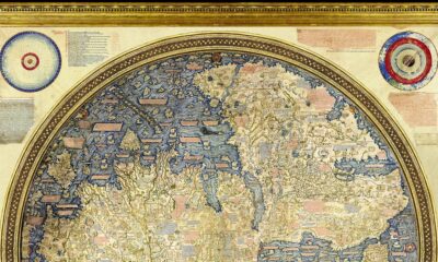
A Babylonian clay tablet helped unlock an understanding for how our ancestors saw the world.
Dating all the way back to the 6th century BCE, the Imago Mundi is the oldest known world map, and it offers a unique glimpse into ancient perspectives on earth and the heavens.
While this is the first-known interpretation of such a map, it would certainly not be the last. Today’s visualization, designed by Reddit user PisseGuri82, won the “Best of 2018 Map Contest” for depicting the evolving shapes of man-made maps throughout history.
AD 150: Once Upon A Time in Egypt
In this former location of the Roman Empire, Ptolemy was the first to use positions of latitude and longitude to map countries into his text Geographia. After these ancient maps were lost for centuries, Ptolemy’s work was rediscovered and reconstructed in the 15th century, serving as a foundation for cartography throughout the Middle Ages.
1050: Pointing to the Heavens
The creation of this quintessential medieval T-and-O Beatine map is attributed not to an unknown French monk, but to the Spanish monk Beatus of Liébana. Although it shows several continents—Africa, Asia, and Europe—its main objective was to visualize Biblical locations. For example, because the sun rises in the east, Paradise (The Garden of Eden) can be seen pointing upwards and towards Asia on the map.
1154: The World Turned Upside Down
The Arabic geographer Muhammad al-Idrisi made one of the most advanced medieval world maps for King Roger II of Sicily. The Tabula Rogeriana, which literally translates to “the book of pleasant journeys into faraway lands”, was ahead of the curve compared to contemporaries because it used information from traveler and merchant accounts. The original map was oriented south-up, which is why modern depictions show it upside down.
1375: The Zenith of Medieval Map Work
The Jewish cartographer Abraham Cresques created the most important map of the medieval period, the Catalan Atlas, with his son for Prince John of Aragon. It covers the “East and the West, and everything that, from the Strait [of Gibraltar] leads to the West”. Many Indian and Chinese cities can be identified, based on various voyages by the explorers Marco Polo and Sir John Mandeville.
After this, the Age of Discovery truly began—and maps started to more closely resemble the world map as we know it today.
1489: Feeling Ptolemy and Polo’s Influences
The 15th century was a radical time for map-makers, once Ptolemy’s geographical drawings were re-discovered. Henricus Martellus expanded on Ptolemaic maps, and also relied on sources like Marco Polo’s travels to imagine the Old World. His milestone map closely resembles the oldest-surviving terrestrial globe, Erdapfel, created by cartographer Martin Behaim. Today, it’s preserved at the Yale University archives.
1529: A Well-Kept Spanish Secret
The first ever scientific world map is most widely attributed to the Portuguese cartographer Diego Ribero. The Padrón Real was the Spanish Crown’s official and secret master map, made from hundreds of sailors’ reports of any new lands and their coordinates.
1599: The Wright Idea
English mathematician and cartographer Edward Wright was the first to perfect the Mercator projection—which takes the Earth’s curvature into consideration. Otherwise known as a Wright-Molyneux world map, this linear representation of the earth’s cylindrical map quickly became the standard for navigation.
1778-1832: The Emergence of Modern World Maps
The invention of the marine chronometer transformed marine navigation—as ships were now able to detect both longitude and latitude. Jacques-Nicolas Bellin, a French geographer, was responsible for the 18th century’s highly accurate world maps and nautical charts. His designs favored functionality over the decorative flourishes of cartographers past.
Finally, the German cartographer and lawyer Adolf Stieler was the man behind Stieler’s Handatlas, the leading German world atlas until the mid-20th century. His maps were famous for being updated based on new explorations, making them the most reliable map possible.
Is There Uncharted Territory Left?
It is worth mentioning that these ancient maps above are mostly coming from a European perspective.
That said, the Islamic Golden Age also boasts an impressive cartographic record, reaching its peak partially in thanks to Muhammad al-Idrisi in the 11th century. Similarly, Ancient Chinese empires had a cartographic golden age after the invention of the compass as well.
Does this mean there’s nothing left to explore today? Quite the contrary. While we know so much about our landmasses, the undersea depths remain quite a mystery. In fact, we’ve explored more of outer space than we have 95% of our own oceans.
If you liked the visualization above, be sure to explore the world’s borders by age, broken down impressively by the same designer.


United States
Charted: What Southeast Asia Thinks About China & the U.S.
A significant share of respondents from an ASEAN-focused survey are not happy about rising American and Chinese influence in the region.
What Southeast Asia Thinks About China & the U.S.
This was originally posted on our Voronoi app. Download the app for free on iOS or Android and discover incredible data-driven charts from a variety of trusted sources.
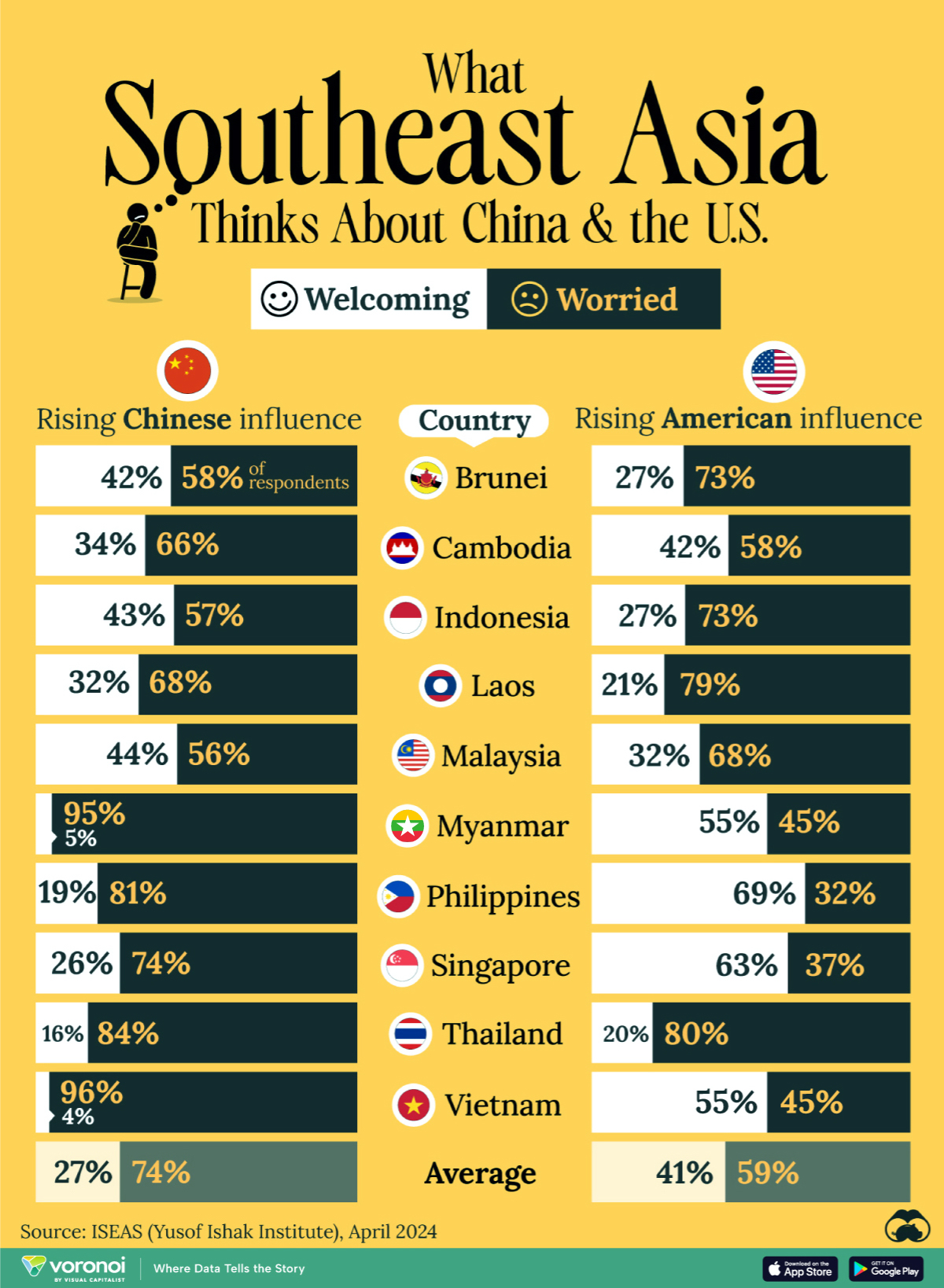
This chart visualizes the results of a 2024 survey conducted by the ASEAN Studies Centre at the ISEAS-Yusof Ishak Institute. Nearly 2,000 respondents were asked if they were worried or welcoming of rising Chinese and American geopolitical influence in their country.
The countries surveyed all belong to the Association of Southeast Asian Nations (ASEAN), a political and economic union of 10 states in Southeast Asia.
Feelings Towards China
On average, a significant share of respondents from all 10 countries are worried about rising influence from both the U.S. and China.
However, overall skepticism is higher for China, at 74% (versus 59% for U.S.).
| Country | Worried About Growing 🇨🇳 Influence | Welcome Growing 🇨🇳 Influence |
|---|---|---|
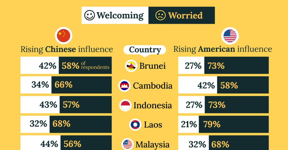
| 🇧🇳 Brunei | 58% | 42% |
| 🇰🇭 Cambodia | 66% | 34% |
| 🇮🇩 Indonesia | 57% | 43% |
| 🇱🇦 Laos | 68% | 32% |
| 🇲🇾 Malaysia | 56% | 44% |
| 🇲🇲 Myanmar | 95% | 5% |
| 🇵🇭 Philippines | 81% | 19% |
| 🇸🇬 Singapore | 74% | 26% |
| 🇹🇭 Thailand | 84% | 16% |
| 🇻🇳 Vietnam | 96% | 4% |
| Average | 74% | 27% |
The recently-cooled but still active territorial concerns over the South China Sea may play a significant role in these responses, especially in countries which are also claimants over the sea.
For example, in Vietnam over 95% of respondents said they were worried about China’s growing influence.
Feelings Towards America
Conversely, rising American influence is welcomed in two countries with competing claims in the South China Sea, the Philippines (69%) and Vietnam (55%).
| Country | Worried About Growing 🇺🇸 Influence | Welcome Growing 🇺🇸 Influence |
|---|---|---|
| 🇧🇳 Brunei | 73% | 27% |
| 🇰🇭 Cambodia | 58% | 42% |
| 🇮🇩 Indonesia | 73% | 27% |
| 🇱🇦 Laos | 79% | 21% |
| 🇲🇾 Malaysia | 68% | 32% |
| 🇲🇲 Myanmar | 45% | 55% |
| 🇵🇭 Philippines | 32% | 69% |
| 🇸🇬 Singapore | 37% | 63% |
| 🇹🇭 Thailand | 80% | 20% |
| 🇻🇳 Vietnam | 45% | 55% |
| Average | 59% | 41% |
Despite this, on a regional average, more respondents worry about growing American influence (59%) than they welcome it (41%).
Interestingly, it seems almost every ASEAN nation has a clear preference for one superpower over the other.
The only exception is Thailand, where those surveyed were not a fan of either option, with 84% worried about China, and 80% worried about the U.S.

-

 Culture6 days ago
The World’s Top Media Franchises by All-Time Revenue
-

 Science2 weeks ago
Visualizing the Average Lifespans of Mammals
-

 Brands2 weeks ago
How Tech Logos Have Evolved Over Time
-

 Energy2 weeks ago
Ranked: The Top 10 EV Battery Manufacturers in 2023
-
 Countries2 weeks ago
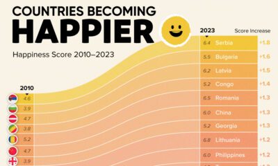
Countries With the Largest Happiness Gains Since 2010
-

 Economy2 weeks ago
VC+: Get Our Key Takeaways From the IMF’s World Economic Outlook
-

 Demographics2 weeks ago
The Countries That Have Become Sadder Since 2010
-
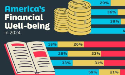
 Money1 week ago
Charted: Who Has Savings in This Economy?